
At a time when mobility infrastructures have become indifferent to their locational context, it is appropriate to reflect on how to intervene in and humanise these infrastructures, improving their relationship with the environment and the citizens they serve. All these infrastructures cannot just be ignored or destroyed. Rather, they can be relaunched, reconsidered and renewed.
The present paper aims to explore the intervention and recycling possibilities of different infrastructures according to their morphology and conception. Through intervention, the goal is to assimilate new challenges and, above all, provide projects with transformational tools. The process brings together all that we have learned over the years in our work with the RiConnect network.
The future of mobility calls for a paradigm shift in which the importance of the private vehicle and the problems and externalities associated with it are reduced. To achieve this, mobility and the artefacts supporting it need to be reconsidered in favour of people-oriented mobility. It must be efficient and equitable, and should ensure the quality of public spaces, connection with urban centres, and the structuring of future developments.
The European RiConnect network has classified infrastructures into three types according to their morphology and scope of intervention. The first of these are linear infrastructures, characterised by one dimension prevailing over the rest; roads, railway lines and even water networks are good illustrations. The second are nodal infrastructures, where an intersection exists within a distribution network, as in mobility hubs, for example. And last but not least, enclosed infrastructures refers to spaces with sufficient entity that correspond to infrastructures that are either obsolete or dilapidated.
We tend to imagine linear infrastructures as being one-dimensional, but in fact they are much more complex and multi-scale: they are spaces whose integration can be achieved by working at three complementary[1] scales or levels. Thus, the key to the effective integration of linear infrastructures lies in a combination of three approaches: longitudinal (territorial scale), transversal (local scale) and contact (detailed scale).

Example of linear infrastructure, highway in northern Spain, 2007. Own development.
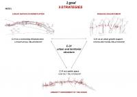
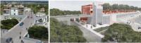
Urban transformation of the C-31 (AMB), a three-strategy scheme.
In the first place, the road’s length provides a longitudinal relationship and ensures its connectivity. The integration proposal seeks to diversify the linear services offered by the road, in order to transition from a segregated road with a single linear service (private mobility) to a combined road with maximum possible services (public and private transport, as well as active mobility).
This approach should also allow us to understand the territory traversed by the infrastructure. If landscape is to be understood as “an area, as perceived by people, whose character is the result of the action and interaction of natural and/or human factors”,[2] linear infrastructures must function as an instrument for citizens to discover the territory, the tool that allows them to understand its identity.
Secondly, the transversal approach supports the improvement of connections between both sides of the infrastructure, ensuring the adequacy, sufficiency and quality of crossings. These infrastructures therefore become key elements for urban connectivity, and ecological and environmental infrastructure.
Finally, the contact scale proposes to work on the edges of the infrastructure and give them a new urbanity, to change the city that historically has neglected its infrastructure, this time confronting it as a positive and dynamic element. It is a question of activating ground levels and edges, rearranging urban fabrics, re-programming historically residual spaces, and thus re-connecting the whole system.
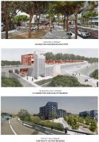
Photomontages of the C-31 Delta (AMB) project, showing each of the three approaches: linear, transversal and contact.
The result is a recycled infrastructure that is no longer a barrier. Its edges have been rejuvenated, it plays a more active role and it integrates ecosystem functions. Essentially, it is an element that continues to be linear and connecting, but at the same time connects and qualifies its immediate surroundings.
With a nodal infrastructure, there are other elements to be addressed. In order to improve its integration, the infrastructure must be treated as an urban element without relinquishing its functional efficiency.
Mobility nodes include stations, BRT stops, car parking, buses, bicycles and pedestrians, etc., thus favouring the interchange between modes of transport and multiplying travellers’ possibilities. Due to their significance, these infrastructures should also be able to concentrate their complexity in a careful and conscientious design, achieving new architectural images. These infrastructures support intermodality, but they also have to grow into hubs that articulate free spaces and concentrate activities.

Intermodal node example, Voorburg, The Netherlands. Web Architizer (02/04/2022)
The integration of this type of infrastructure will be achieved by developing these nodes in three-dimensional space. In this case, width, length and depth become the project elements to work on. Moreover, it will be necessary to consider the transformation’s impact as a catalyst for a new identity in its immediate surroundings.
It is a question of working with the three dimensions conjointly. It is necessary to understand that the city may have different levels, that it can approach the infrastructure methodically and narrow the space dedicated to the road or the train (reduction of residual spaces) in favour of creating greater intensity.
By means of vertical design, it is possible to relate the upper dimension to the lower, overlapping uses and layers, parasitising the infrastructure by adding programme and complexity. All this should take place while understanding that the infrastructural element must be subordinate to its integration without sacrificing efficiency.
Meanwhile, the horizontal approach will generate attractive, wide, convenient crossings, blurring the limits of the infrastructure in order to bring citizens closer to these optimum connectivity points. At this stage, it is also very important to reconsider sector-specific regulations and be able to adapt any infrastructural easements to the demands of the intermodal node.
Nodal infrastructure integration, Walnut Street Bridge, Philadelphia and Sky train, Okinawa.
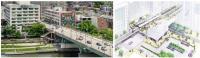
Nodal infrastructure integration, C-31 Llobregat Delta (AMB) project.

Nodal infrastructure integration, Mira-sol station, Sant Cugat del Vallès. Web TAC Architects (02/04/2022)
The result of this integration is the creation of new metropolitan crossings where, through overlapping and accumulation, we are able to generate new high urban intensity points (centralities) and sow the seed for the regeneration of existing fabrics.
Finally, enclosed infrastructures involve a considerable extension of land to be classified and improved: for example, parks, cemeteries, military zones, railyards, port areas or airfields that have become obsolete over time, or even nondescript neighbourhoods or urban fabrics with no defined character.
Enclosed infrastructures have two main elements: the borders, and the interior space. The boundaries are often impermeable or impassable, while the interior lacks content and character. The integration proposal must address both these elements.
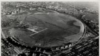
Example of enclosed infrastructure. Tempelhof Airport in Berlin. ABC newspaper website (02/04/2022)
These infrastructures must be rethought in line with the identity of the territory. A precise reading of the location of the site should be conducted to determine its underlying structure, followed by the elaboration of urban improvement proposals from this starting point: understanding the site is the first step in the project process.
In this case, the objective is to structure and relate, give the site a new hierarchy, create a network, and interrelate the interior and the exterior; in other words, to soften its edges and connect the site with its surroundings. The target is to create a clear and powerful structure that can convey public interest and the success of future actions in the short, mid and long term.
To open up an enclosed infrastructure means to interpret the biophysical and environmental mesh and understand its history, while achieving greater permeability. This new support will be the skeleton of the enclosure, creating a powerful yet versatile network that prioritises quality over quantity, and above all articulates and connects the local with the territorial scale.

Site infrastructure, park Duisburg Nord, Germany. Biennial landscape website (02/04/2022)
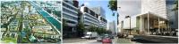
District infrastructure, Rive Gauche project in Paris, France. Web Institut Paris Region (02/04/2022)
These three project approaches, according to infrastructure type, are the recapitulation of the ideas and contributions developed over the course of these years of reflection. All three approaches are different and have been adapted to each case, while maintaining a unique common thread: rethinking, transforming and integrating mobility infrastructures means intervening in them.
1) More than lines. Article by Eugenia Vidal (AMB) for the Transnational Meeting 5 of the RiConnect Network.
2) Article 1 of the European Landscape Convention, signed in Florence, on October 20, 2000.
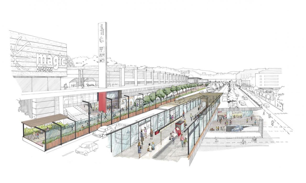
Cover image: Urban transformation of the C-31 (AMB), artist rendering. Felipe Ibarz / AMB.
![]()