Summary
For the Agence d'urbanisme Bordeaux métropole Aquitaine (AURBA), accepting that society functions as a network is central to understanding the changes at work in urban and metropolitan systems. In 2016, they produced an atlas of the metropolitan spaces of Bordeaux (FR) that not only analyses the evolution of factors like population, employment and mobility, but also shows exchanges with other territories.
The idea is that this “relational approach” to certain spaces enables the notion of changing reality to be integrated into their development and urban management. In this way territories can be understood according to their interdependency and interconnections, rather than in terms of distribution and localisation alone.
The atlas builds on the conviction that in a context of diminishing public resources and inward-looking attitudes, improving familiarity with, and understanding of, our neighbours fosters greater openness and new forms of partnership.
The solutions offered by the good practice
Metropolisation is a process. Our analysis does not focus on a finished geographic object, but rather seeks to shed light on dynamic processes and trends. Our angles of interpretation and perimeters are multiple. Pre-existing limits are discarded in favour of explorations of territories fashioned by exchange networks.
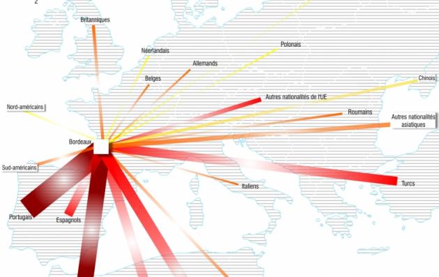
The Bordeaux metropolitan area is varied in nature - Bordeaux exchanges employees with the Arcachon basin and Libourne, patients with La Rochelle and Toulouse, clients with Bayonne and Langon, second home owners with Royan and Périgueux, spectators with Angoulême and Toulouse, engineers and editors with Paris and Lyon, tourists with Barcelona and London, students with Bucharest and Dakar, researchers with Munich and Los Angeles, and bottles of wine with the whole world. Our aim is to promote ways of developing territorial strategies in full knowledge of the forces at work, the existing stocks, interactions and exchange networks.
Whether metropolisation is to be endured or desired, ignored or regulated, it concerns everyone. The issues at stake are thus extremely numerous - demography, migration, employment, the economy, public facilities, services, the environment, tourism, local resources. In addition to exhaustive monographs of stabilised perimeters and detailed indicators, dynamic explorations are also presented, with a view to comparing and contrasting different scales, themes and objects of observation (as well as exchanges and stocks).
Building on the sustainable and integrated approach
Over and above urban challenges, specifically territorial challenges lie at the heart of this atlas. Understanding the functional reality of a territory, by comparing and contrasting themes and scales is the raison d’être of this work, as a means of shaping a global, structuring vision of how territories function.
This approach examines a variety of interrelated themes: the environment (water resources, nature reserves etc.), the economy (links between head offices and branches, patents, exports etc.) or social factors (residential migration, utilities and public facilities, etc.). Horizontal thematic integration is essential if we are to gain a full grasp of the metropolisation phenomenon.
This comparative approach is also adopted in terms of spatial scale, as a means of exploring this subject on a comprehensive level. Metropolisation is of course a large-scale phenomenon, taking place on the European or world scale, but it is first and foremost a daily development, clearly observable in cities and neighbourhoods.
Based on a participatory approach
A participative approach has not been implemented in the development and production phase. The complexity of the phenomenon under study is such that it demanded the formation of an academic committee comprising researchers in the field of geography and experts in data analysis and cartography.
The most significant phase is now commencing, with the delivery of our first results for discussion. These findings were initially addressed to political decision-makers, as they are directly responsible for managing territorial resources.
The light shed on existing and upcoming partnerships makes it possible to make budget savings by offering support to ongoing dynamics (be they social or economic). The results are also of interest to people living in the areas studied. People across the region have shown a clear interest in our research and cartography during public presentations of our work.
What difference has it made?
As described above, our research aims to shed light on areas of effective partnership between territories, towns and cities. In the current climate, it is becoming increasingly necessary for services, facilities and resources of all natures to be pooled, and towns will be able to build on our findings to begin to work with rather than against each other. This will make way for the creation of new structures on which partnerships may be founded, such as the “Metropolitan Poles” already in action across France, through which territories commit to clearly defined cooperation goals in a range of precise areas (e.g. academia, culture, economic development).
Why should other European cities use it?
Metropolisation is a process which affects the whole of Europe, both in urban, peri-urban and rural environments. While major conurbations often see it as a positive element, rural and outlying areas seem to endure rather than control it. Tracing the contours of the process shows that, in reality, all territories have their part to play and that rather than merely modifying the size of our towns, a whole set of measures and policies of an inherently local nature are driving this trend.
If metropolisation is inevitable, then it is important that it be understood by all, and that all territories should play their role to the full.
-
275_Bordeaux_Gpsummary.pdf(PDF, 26Ko)