
The Porto Metropolitan Area covers a vast territory with dispersed population. This offers a great diversity, resulting in an area of fantastic beauty suitable for living, investing or tourism. However, it also poses mobility challenges and a great dependency on car traffic, and RiConnect wants to help overcome such issues by better integrating mobility in urban areas.
AMP is an intermunicipal entity aimed at fostering cooperation both among municipalities and between institutions in charge of supramunicipal networks. Its main duties include promoting the planning and management of the economic, cultural, social and environmental development strategy; articulating municipal investments of intermunicipal interest; managing programmes to support regional development; and planning actions associated with public entities.
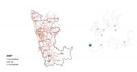
The Porto Metropolitan area and its location in Europe
Since it was founded in 1991 by 9 municipalities, the AMP has grown and is now comprised of 17 municipalities. There have been four important milestones in the composition of AMP:
1991 Founding | 9 municipalities | Espinho, Gondomar, Maia, Matosinhos, Porto, Póvoa de Varzim, Valongo, Vila do Conde and Vila Nova de Gaia | 1 NUT III |
2003 1st Enlargement | 14 municipalities | Arouca, Santa Maria da Feira, Santo Tirso, São João da Madeira and Trofa | 3 NUT III |
2008 2nd Enlargement | 16 municipalities | Oliveira de Azeméis and Vale de Cambra | 3 NUT III |
2013 3rd Enlargement | 17 municipalities | Paredes | 1 NUT III |
Stages in the formation of the Porto Metropolitan Area
AMP is located in the Northern Region of mainland Portugal in the northwest of the Iberian Peninsula. It is bordered to the west by the Atlantic Ocean, to the north by CIM Cávado and CIM Ave, to the east by CIM Tâmega e Sousa and CIM Dão-Lafões and to the south by CIM of Aveiro. AMP occupies an area measuring 2,041 km2. The most extensive municipality is Arouca, with 329 km2, and the smallest is S. João da Madeira, with 8 km2. Area-wise, AMP represents 10 % of the North Region and 0.2 % of Portugal’s mainland. It consists of 27 cities and 69 villages, which correspond to 50 % of the cities in the Northern Region and 18 % of the total cities in mainland Portugal. Due to its diverse composition, AMP has a rich natural and cultural heritage. Therefore, it is an area of fantastic beauty and incredible potential, whether for living, investing or tourism.
Regarding its place in the national urban system, Porto Metropolitan Area is one of the two major conurbations in Portugal. There are medium-sized urban areas in the north and south of AMP, such as Póvoa de Varzim and Vila do Conde, Trofa and Santo Tirso (in the north) and Oliveira de Azeméis (in the south). The central area of AMP is the most urbanised, covering the municipalities of Porto, Matosinhos, Maia, Gaia, Valongo and Gondomar.
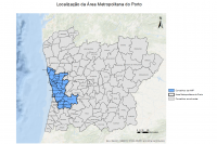
Composition of the Porto Metropolitan Area
In 2019, AMP had 1,728,226 inhabitants, 47 % of whom were male and 53 % female. The most populous municipality is Gaia, with more than 300,000 inhabitants, while the least populous is Arouca, with almost 21,000 inhabitants. However, the municipalities with the highest population density are Porto, Matosinhos and S. João da Madeira.
The space occupation in the AMP is not uniform at either the metropolitan or municipal level. The way people are distributed directly relates to the way infrastructures, means of communication and economic activities are organised. Consequently, the most densely populated municipalities are those with the largest area of urbanised land, that is, the most central municipalities in the AMP. Activities related to the tertiary sector and industry are also concentrated in these municipalities, while agriculture and forestry are still very present in the most peripheral municipalities.
The population dispersion in the AMP, combined with a mobility system focused essentially on road transport, contributes to the fact that private car mobility represents 69 % of the modal split. Road infrastructure plays a fundamental role in the way mobility is organised in the territory: cars have been at the core of mobility planning for a long time, and this is reflected in the way the road network is organised at the regional and local level. However, internal travel within the AMP is still very time-consuming: moving between some municipalities still takes too long, and not the entire metropolis is served by motorways. One of the projects foreseen in the Metropolitan Mobility Plan is the construction of a first-level high-quality network that allows for rapid movement and accessibility between the AMP municipalities and good connections among the existing local networks.
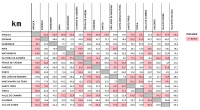
Travel distance between the City Councils of each municipality
The improvement of the road network and its conditions also depends on a greater balance between the different modes of transport. Consequently, there are several projects taking place in the AMP that aim to promote the use of public transport (such as the Reduction Support Programme Fee – a reduction in the price of transport tickets, and the extension of Metro do Porto - construction of two new lines) and soft mobility (expansion of the bicycle network).
The area that AMP selected for the RiConnect project is a showcase of most of the urban and mobility challenges in the metropolis: heavy traffic, lack of safety for cyclists and pedestrians, absence of public space and green areas, difficulties using public transport, territories segmented by roads, etc. This area has an enormous potential to experiment with solutions that reverse the current trend and can serve as good practices to be replicated in the rest of the AMP territory. In addition, experiences with other metropolitan partners can offer innovative solutions to AMP’s problems.
Therefore, RiConnect is a very important opportunity for AMP to advance towards better mobility and urban planning.
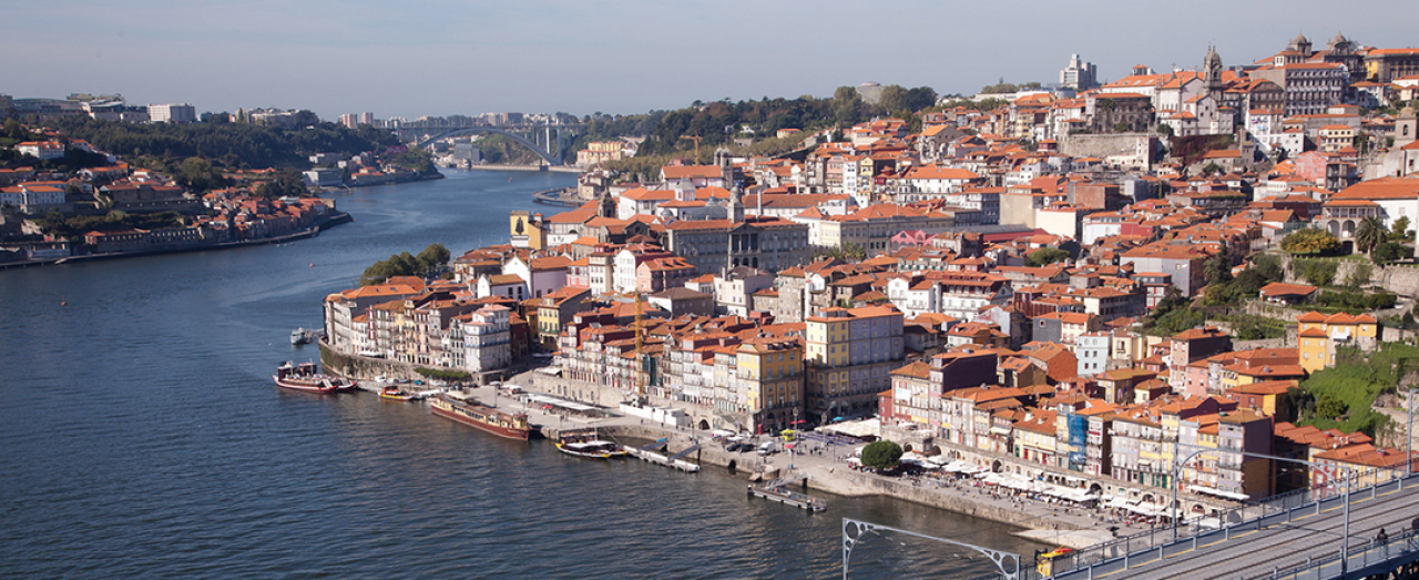
Cover image: City of Porto @ A Caixa Negra