How are towns and cities rebuilding streets for people, not cars? Answers in the latest URBACT Walk and Roll Cities webinar…
It is a well-known fact that car-oriented urban development in the second half of the 20th century led to pollution, congestion and other serious problems, with quality of life deteriorating dramatically in many areas. These unfortunate developments did not occur by themselves, they were brought about by systematic political and planning interventions favouring car use.
In the United States, for example, 44 000 miles of publicly funded motorways were built in the 1950s, interlinking large cities and cross-cutting their city centres. Moreover, the price of oil was kept at an artificially low level and large mortgage subsidies were given to single-family house builders and infrastructure subsidies to suburban settlements.
The outcome of these policies in the US was widespread suburbanisation and urban sprawl. Similar tendencies were also seen in European cities, although in most European countries, the control over land use was stricter and public subsidies for car-oriented development were more limited. Even so, there were lasting visible changes, for example wide streets replaced demolished historic areas in central Stockholm, in northern Brussels, and in a number of British inner cities.
In the 21st century, cities across the EU started rethinking mobility and public space, attempting to correct earlier mistakes and promoting car alternatives. Their new visions and tools were the focus of URBACT’s latest #WalkAndRollCities webinar. Held on 5 April 2022, the online talks brought leading urban mobility and public space experts together with more than 80 participants from URBACT cities and beyond.
‘Re-humanising’ cities
Reversing the dominance of cars in our cities is not impossible: again, systematic political and planning interventions are needed, this time in the opposite direction from the 1950s. New, parallel and interlinked changes in mobility and public space development must aim to limit car use and support active travel modes, while transforming public spaces in order to benefit residents.
For such a re-humanising agenda, the overarching concept of Levine-Grengs-Merlin (2019) can be taken as one of the starting points. Their book ‘From Mobility to Accessibility: Transforming Urban Transportation and Land-Use Planning’ describes the idea that transportation planning and the transportation dimensions of land-use planning should be strongly connected and based on people's ability to reach destinations, rather than on their ability to travel fast. The primacy of mobility – how far you can go in a given amount of time – should be replaced by a priority given to access – how much you can get in a given amount of time. The new approach should be based on connectivity (being connected to online tools and networks, enabling some activities without physical relocation), proximity (bringing city services closer to one another in space) and innovated mobility (taking an integrated approach to promote public transport as a backbone for the remaining mobility needs).
As described in one of my earlier articles, the #WalkAndRollCities cooperation was launched by three URBACT networks: RiConnect, Space4People and Thriving Streets. Their most recent webinar explored the best ways for cities to plan and implement new public space visions and innovative mobility tools. Here are some highlights…
1. New public space visions
The 15-minute city vision
|
|
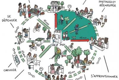
Figure 1. The 15-minute city, Source: Paris en Commun |
Carlos Moreno, Scientific Director of the ETI Chair, Sorbonne University – IAE Paris, is the best-known inspiring person behind the idea. He showed how this vision aims to humanise cities through creating a new urban lifestyle in ‘15-minute neighbourhoods’. As Jane Jacobs suggested: the real capability of a city is to offer multiplicity of choice under all circumstances. Places must be viable, liveable, equitable and most of the necessary functions should be reached within 15 minutes in dense urban areas – or within 30 minutes in the case of less dense territories.
Proximity solutions are based on six basic factors: work, supply, caring, learning, enjoying, living. And in all of these, monofunctional solutions have to be broken up into interrelated wellbeing, sociability, and sustainability factors. There are three rules for mixing uses within proximity: chrono-urbanism (a new rhythm of the city), chronotopia (multipurpose functions of given places), and topophilia (love of the place).
Carlos Moreno is also set to speak at the URBACT City Festival on 14 June 2022. More detailed information about the 15-minute city vision is available here.
The superblock vision
Ariadna Miquel, Director of Urban Strategy at the Chief Architect Office, Barcelona City Council, put the spotlight on Barcelona’s ‘superblock’ programme, a well-known, brave attempt to innovate the city. Actions include the recovery of high-quality public spaces, CO2 reduction, greening, pedestrianisation, and sustainable mobility. Superblocks, or ‘Superillas’, constitute one of the key ideas in the regeneration of the city. The idea emerged in the 1990s by Salvador Rueda, but it was not until 2016 that it became widely known due to the Superilla implemented in the Poblenou area of Barcelona.
|
|
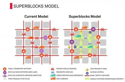
Figure 2. The superblock model, Source: Ajuntament de Barcelona |
The basic idea of a superblock is to exclude through-traffic of non-resident cars from a designated area of three-by-three blocks, assigning the inner streets and squares as shared-use space, with priority to walking. This means that everyone in the superblock has access to green and public spaces – and cyclists and pedestrians take over the space previously used by cars. After initial debates, the Publenou superblock became accepted and beloved by residents, particularly when picnic tables were installed in the inner streets (see more details in this article).
Recently, the city has been scaling up the idea: six superblocks are under development in Barcelona, and in the longer run the municipality intends to create over 500 such areas. Also, the ‘Superblock Barcelona’ idea has emerged, with green streets connecting local projects to one another. So far, 21 of these streets have been planned, fully redesigning the streetscape, and changing crossings into liveable squares. The first of these green streets will be developed in summer 2022.
2. New mobility innovations
The Tempo 30 idea
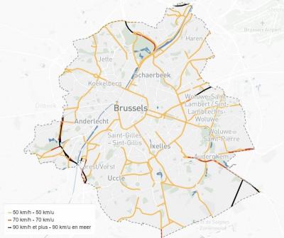
The Brussels region consists of 19 municipalities, where more and more 30 km/hour speed limitations have been introduced since 2010. Presenting the Tempo 30 idea, Kristof De Mesmaeker, Directeur Mobiliteit en Verkeersveiligheid @ Brussel Mobiliteit, said the breakthrough came in 2019, when a new government was elected with the following political programme: “The government will create one big zone of 30 km/h from 1 January 2021, with exceptions on the biggest roads.” This political programme has been implemented in recent years. Of course, initially many actors resisted the idea, however, rather than reacting to everyone, the city focused mainly on the programme’s supporters.
|
|
Figure 3. The map of the Brussels Tempo 30 area, Source: Brussels Mobility |
Tempo 30 became the new normal, thus the 4 000 ‘zone 30’ signs were removed and new ‘Tempo 50’ signs were put up in specific areas with a higher speed limit. Communication was very important: all public services advertised the idea and information was mailed to 600 000 addresses. The press and social media were full of news about the change. The implementation was carefully steered and speed controlling was strengthened, thanks to 80 invisible new cameras.
As a result, recent monitoring shows that the average speed of cars decreased, even on roads that already had 30 km/hour speed limits earlier. Total car journey times increased, but not much, while the number of accidents dwindled. Noise levels decreased: people even started to complain about the noise of the tram, previously hidden by louder road users. Further materials on the Tempo 30 programme in Brussels are available here.
Parking management
Robert Pressl, mobility expert and consultant, Graz (AT), described powerful tools to free public space from being occupied by cars. Figures from Graz prove the very unjust use of space: parked cars occupy 92% of public space while their share in modal split (traffic) is 47%. The UVAR – Urban Vehicle Access Regulations – method includes onstreet parking space management, using tools such as time limits, restricting access to certain groups, charging fees, or marking areas where parking is prohibited.
One of the innovative tools is multiple parking facilities, in the form of shared parking, for example using theatre parking for offices during the day, or downtown parking for local residents during the night. Copenhagen (DK) is making parking in front of schools available for bike parking between 8:00 and 17:00. In Vienna (AT), the average time to find a parking space, responsible for 30% of traffic flow, was reduced from 9 to 3 minutes in districts 6-9 after implementation of parking space management, and Munich (DE) has achieved similar success. It is important to make complementary improvements, such as improving the pavement when introducing paying parking, as seen in Sofia (BG), or establishing Parking Benefit Districts for the use of extra revenues.
In Amsterdam (NL), parking fees amount to 160 million eur/year, of which 38% funds management of the system, while the rest is spent on improving public spaces in the city. In Lisbon (PT), a programme named ‘Uma Praca em Cada Bairro’ (A square in every neighbourhood) is fostering the car-free rehabilitation of key public squares in the city with the aim of getting people out of cars and turning roads into public space, making the city more people friendly. Further materials on SUMP and parking management are available here.
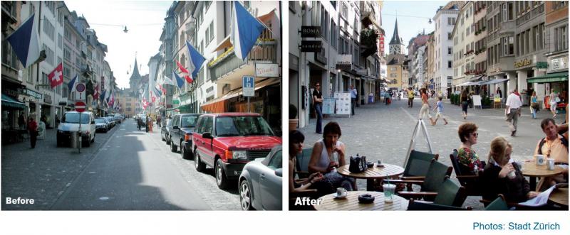
Figure 4. The effect of parking management in Zürich, Source: CIVITAS, PARK4SUMP
Watch the video recordings of the Walk’n’Roll webinar presentations
URBACT cities share their experiences
The URBACT Walk’n’Roll Cities webinar was a chance for representatives of similarly sized cities to exchange experiences. Representatives of larger cities like Graz (AT), Porto (PT), Thessaloniki (EL) and Krakow (PL) raised the importance of political leadership. If a new city leadership is committed to stepping up against car use, many things can be done, like pedestrian zone extension, increasing parking fees, including cycle highways in new public development projects, or creating a bike network for the whole area. There are, however, also examples of reverse trends, where a period of successful pedestrianisation might be followed by more car-oriented development, reflecting a new leader’s priorities.
Metropolitan cooperation, across administrative borders, is of key importance in communicating new actions widely and getting them accepted. However, if there is no metropolitan political commitment, and no metropolitan authority exists with sufficient responsibilities, each municipality is likely to carry out its own innovative interventions in its own central area, perhaps only coordinating aspects such as the trains and ticketing system with other municipalities. On the other hand, substantial amounts of EU money can help to create cooperation between the city, the metropolitan organisation and the region – as the case of Polish cities shows.
The group of medium-sized cities highlighted the cases of Edinburgh (UK), Debrecen (HU) and Parma (IT). These cities play with many innovative ideas, such as the 30 km speed limit, shared street use, and incentives for biking to work. There are, however, many barriers to making the cities more sustainable. Critical remarks were raised for example about certain national financial subsidies, for example subsidising travel to work by car.
On the topic of implementing innovative ideas, obstacles in governance, institutions, and financing were discussed. Examples ranged from the discontinuation of a biking lane due to complaints from elderly people, to regional level blocking of strict parking regulations in a city, as surrounding municipalities opposed restrictions against car use.
Webinar participants agreed that the public sector should oppose the view that people have unlimited right to use cars. But there was a debate about how far regulatory restrictions can go, if many people do not agree or cannot go along with the changes? For example, progress towards biking solutions is complex in our ageing society.
Tips for a successful shift towards ‘soft’ mobility
It was a common view that the best approach is first to discuss the vision at city or metropolitan level, before introducing any measures affecting residents. Barcelona was identified as a positive example for such systematic policy development efforts, correcting some initial mistakes. The objection bias (the usual fact that citizen groups opposing restrictions are louder than those who would support the changes) can be handled with systematic co-creation efforts from the beginning. It is very important to educate decision-makers, not only about the innovative visions and tools, but also about how to implement such progressive changes.
How to link visions and tools on different territorial levels
The next task for the URBACT Walk’n’Roll Cities partnership is to explore potential links between the visions and tools for developing people-centred urban areas, raising new ideas on the basis of innovative city approaches. Investigations will focus on different territorial levels: metropolitan-wide (integrated system with Park+Ride, metropolitan boulevards); city wide (15-minute city neighbourhoods and superblocks with Tempo 30 and parking management solutions); neighbourhood-based (car-free neighbourhood with circular roads, pedestrianisation, shopping streets, green squares).
All these issues will be discussed at the URBACT Walk’n’Roll Cities final event, a face-to-face seminar in Barcelona, on 6-8 July, hosted by Àrea Metropolitana de Barcelona.
Read more on the #WalkandRollCities cooperation and our final event in a LinkedIn discussion group, where you can discover the products of the three URBACT networks dedicated to improving urban mobility and shared space – and join the conversation on #WalkandRollCities!